Geology
Mull has been described as a ‘Mecca' for geologists with its classic geological sites of world interest. Pennyghael on the southern shore of Loch Scridain is the ‘gateway' to the main geological wonders of this amazingly varied and well exposed island. For several decades British geology and geography students have enjoyed field courses to Mull. Pennyghael is the perfect location from which to visit all Mull's most fascinating areas without the necessity of spending an excessive time travelling.
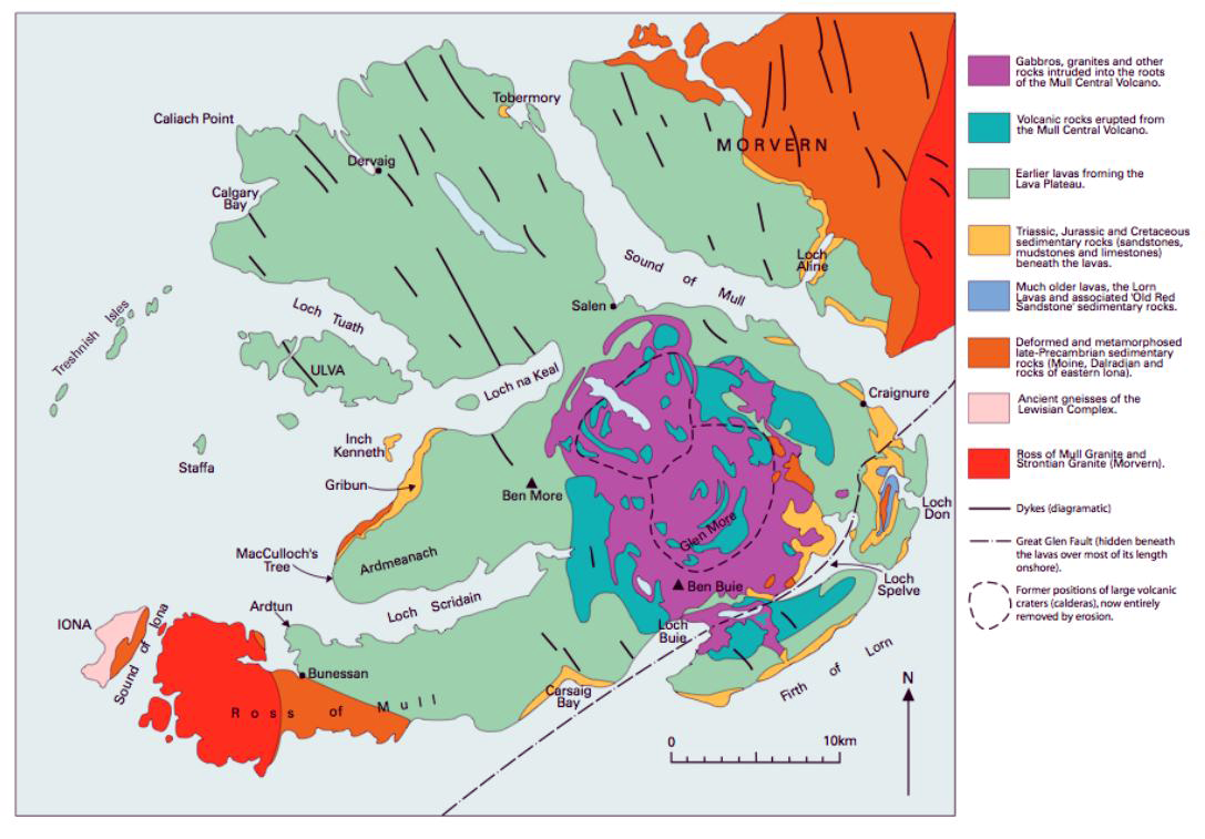
Situated on the southern shore of Loch Scridain upon the stepped lava flows of Brolass, Pennyghael looks north to 3,172' Ben More, a unique fold in the lava clearly visible at its base. South of Pennyghael, at Carsaig some of Mull's Mesozoic sediments, Jurassic and Cretaceous in age are well exposed in the large bay. East of Pennyghael, through the ice carved Glen More lies Mull's amazing igneous complex with its large acid and basic intrusions, three volcanic centres of cross cutting cone sheets and ring dykes, including the best preserved ring dyke in the world. Further east Palaeozoic basement rocks of the Lochdon anticline are exposed where Scotland's Great Glen fault slices across Mull. West of Pennyghael on the Ross of Mull Pre-Cambrian metamorphic rocks of the Moine series and a Caledonian granite pluton with classic metamorphic aureole are very well exposed. Finally, a short ferry trip across the Sound of Iona some of the oldest of Britain's rocks, Torridonian sandstones and Lewisian gneiss are exposed on Iona. Dykes from Mull's famous NW-SE trending dyke swarm can be seen in all these areas cutting the older rocks. Mull and Iona's rocks span 2,800 million years of time, from Lewisian gneisses on Iona to the Pleistocene sediments of the last Ice Age which form ‘drift' deposits. The rock cycle is still in progress today with the latest sediments, river gravels and wind blown sand, forming Recent deposits. Physical geologists and geographers are interested in Mull because time has allowed denudational processes to sculpture and shape the land into its present landscape of mountain peaks and table lands, glaciated valleys and emerging rocky shores, skirted cliffs and youthful rivers, some of which plunge from high waterfalls straight into the sea. Add to all this that Mull is arguably the most beautiful of all the Hebridean islands and it is no wonder that Mull is a ‘Mecca' for so many people interested in earth sciences.
Many different excursions can be taken to see Mull's varied geology and scenery and none is more than 30 minutes drive time away from Pennyghael. Some of the many sites of interest are listed below but more information about the geology of Mull can be found in a 40 page book entitled ‘Mull in the Making' which explains Mull's complex geology in a simplified way. This small book comprehensively covers Mull's long geological history in the light of plate tectonics and rock cycles. See below.
Some examples of the many well exposed geological features that can be seen and studied in the field:
North of Pennyghael
- Fold in the lava flow at Ardvergnish.
- Trap topography of Glen Seilisdeir and Ardmeanach.
- Macculloch's fossil tree and emergent coastal scenery at Burg.
- Moine psammites, angular unconformity, Mesozoic sediments at Gribun.
- Base of lavas. Heterolithic unconformity between Cretaceous sediments and Tertiary lavas at Gribun.
- Lava flows, transgressive sills, cross cutting dykes. MacKinnon's sea cave, buried landscape features at Gribun.
- Raised beaches, cliffs and sea caves, young river deltas on Loch na Keal.
- Glacial features including ice smoothed bedrock, p-forms, hanging valleys, arêtes etc.
Carsaig bay area
- Jurassic mudstones and sandstones on marine abrasion surface. Liassic fauna of bivalves, ammonites, and belemnites. Dogger concretions. Dykes, sills, cone sheets, faults, all cut the condensed Mesozoic sequence of Jurassic and Cretaceous sediments. Heterolithic unconformity between Cretaceous and overlying Tertiary basalt lavas.
- Stone run with fallen blocks containing Mesozoic sediments, Tertiary red bole, tachylite, pepperite, basalt, vesicular basalt, amygdaloidal basalt and chalcedonic quartz.
- The Nun's Cave, raised sea cave. Marine abrasion surface of Jurassic shales and sandstones.
East of Pennyghael
- Craig Quarry. Exposed magma chamber. Ben Buie gabbros and dolerites. Megacrysts in pegmatites.
- Glacial morainic features, recessional and end moraines, roche moutonee, lateral moraine, glacial lakes.
- Example of magma differentiation by crystal fractionation on vertical traverse of Cruach Choireadail.
- Composite dyke. Allt Mollach at Ischriff.
- Flow aligned big feldspar dolerite in small bosses.
- Lochdon anticline Palaeozoic inlier.
- Devonian lavas.
- Great Glen fault zone.
Glen More
Lochdon
West of Pennyghael
- Ardtun leaf beds. Interbedded sediments in lower lavas. Columnar basalt scenery. Sills.
- Folded Moine psammites and garnet mica schists.
- Contact between Moine schists and Ross of Mull granite. Metamorphic aureole. Xenoliths. Ptygmatic folds.
- Ross of Mull granite. Xenoliths. Roof pendants. Tors, castellated, and ice smoothed granite scenery.
- Torridonian sandstones and Lewisian gneisses.
- Tertiary dykes cutting these Pre-cambrian rocks.
- Iona marble quarry. Metasomatised limestone. Fold structures.
- Glacial erratic rocks.
Ross of Mull
Isle of Iona
The above suggestions are merely a few examples of the many geological features that can be seen within half an hour's driving time of Pennyghael. There are very many more to be seen further away in the north of Mull. Also there are some excellent sea excursions to the Isle of Staffa famous for its basalt columns and Fingal's cave, and to the Treshnish Isles, which can be made during late spring and summer.
Maps and Books for reference
British Geological Survey Maps:- Mull, Scotland sheet 44, also sheets 43, 51 and 52.
British Regional Geology, Scotland: The Tertiary Volcanic Districts. HMSO.
Geologists Association Guide No.20: The Tertiary Igneous Geology of the Isle of Mull.
Mull in the Making, Rosalind Jones. ISBN 0 9531890 0 7.